Tuesday, November 27, 2012

Mirabella Mountain 2012 Run Report & Buller Road Trip - Part 2 (21k of asking WHY!)

PART 2 - 21k OF ASKING WHY! 

Wow. Sometimes you just have to get out there & live a little u know? My decision to join the Mirabella run was after realising that the Razorback Run was too gungho for a newbie-to-the-area like me. And trust me it was a good decision, I've met wonderful people, made new friends & learnt more about Buller in the summer than many locals i'm sure! :) The run was properly organised, runners were well taken care of & all in all - a stellar effort put in by the organizers & it certainly shows. If you're a runner wondering whether you should consider joining for 2013 & beyond - wonder no more, sign up & you won't regret it. The event is destined for greatness.

Here's my run experience narrated via the colourful medium of pictures:

Friday nite - arriving bit late, everyone had already finished dinner! Tried to sneak in while Hanna was giving a briefing on the lodge, but was duly acknowledged by her & the crowd :) everyone was friendly & I had a wonderful time getting to know many of the organizers & crew members. I crashed early after an exhausting road trip.
Pic courtesy of Sonya Clota.
The next morning. View outside the lodge. I'm not sure whether one can ask for more in terms of view. Weather was holding well - and that only meant INTENSE SUN! 

Back at the lodge after breakfast which was a small bowl of cereal for me - was getting ready & waiting to depart for the registration area - which was about 5mins walk towards the centre of Mt Buller village. No last minute rush or anything so it was definitely a good idea to stay overnight at the lodge. 
Summer it was indeed. Well coming to summer anyway. Entire Buller village is empty & from what I know the whole place will transform come Snow & winter. Jam packed with people & pristine white snow everywhere. Looking forward to seeing that one day.
Waiting for our ride to the starting point & chatting to the runners & getting goose bumps from the breeze. I forgot they were doing baggage drops otherwise would've brought my jacket along..
Pic courtesy of Sonya Clota.
One for the album - group pic of the 21k runners before we set off & make history.
Pic courtesy of Sonya Clota.
Oh wait - before that - warm-up exercises! I think everyone was caught a bit off-guard when the music started & the dance moves started :D in any case it was good fun (everyone seemed keen to get started already!)
Pic courtesy of Sonya Clota.
David Fot & me hopelessly trying hard to get in sync :D
Pic courtesy of Sonya Clota

Here's a clip of us warming-up & being amused!

As soon as we were flagged-off - the elites were off! I think they ran together for another 5k or so before the top dogs started pulling away & the separation was levelled out even more. My own strategy  was just to do my slow 6min/km pace for the first 7k, and incrementally by 30sec for the next 2x 7ks. I knew I could do no faster in my current form. In fact I was ready for pain.

A picture with David at around 2/3k mark.. legs were still feeling fresh & smiles all round! soon to change of course! 
Behind that smile are tired legs! Most likely at the 14/15k mark at this point, not too sure.
18k mark - lovely views. Didn't have the strength to admire for long, was just focused on regulating breathing & hydration & making sure I don't puke coz tummy felt bit funny at this point. 
Chugging along. I remember at this final drink station Hanna running across the road & handing me a wet cloth - grateful for that as it was much needed. I'm surprised my legs were still going at this stage as the agony of the 18k mark was kicking in.. pic courtesy of Sonya Clota
Drink station angels - Hanna & Sandra! Pic courtesy of Sonya Clota
The dreaded Hell Corner at the final 1k. Whoever named these corners must've been a runner !
Doesn't look like much? Trust me after 20k of running uphill - you'll feel every step of this corner!
Soldiering on. The long & lonely journey to the top. Onward march up the final 1k. Picture courtesy of Sonya Clota.
I mentioned about my race preparation - a set of hard-biting teeth. Put in use right here! Picture courtesy of Sonya Clota.
Vanity is.. mustering a gleaming smile for the camera no matter how much pain one is in! Picture courtesy of Sonya Clota.
Prize-giving ceremony - all smiles. I was proud of my time, proud of my efforts & very pleased that everything executed to plan OR it could just be the PERONI beer I had.. :D Pic courtesy of Sonya Clota

History making crew. Mirabella Mountain 2012 participants. Pic courtesy of Sonya Clota
A finisher's medal is actually very meaningful especially after a meaningful run :) While many pro-runners probably would be happy just with the record of their times, I personally won't mind having some kind of memento regardless of my level of run going forward.

While it was 21k of asking WHY - it was also 21k of KNOWING why!

Left - burger + drink for lunch shortly after run. Juicy goodness. Right - Brunch a day later (Sunday) back in Boxhill - Beef noodles, also total juicy goodness. Both highly recommended! :D
Some tour-guiding by Norman & Sandra who brought us up to the very summit & showed me & David around for a bit after our lunch. Found a nice place for coffee too :)
MORE PICTURES HERE - MY FB ALBUM

Post Event Thoughts.

Well I needed all this. I needed to get away & remind myself of the great outdoors is always there. Whatmore now knowing that Victoria is such a beautiful place with so much to offer. I'm already thinking of a possible future where I might be organizing my own trail runs here there everywhere (there's so much potential!) just like the Mirabella folks & their ambitions for the event. All in all I loved the experience & would not hesitate to put this event forward as a race to sign-up for 2013. :)

While I suffer the post-event & post-amazing-weekend blues - I shall have to start focusing on the next run - Thanks for reading & sharing this experience with me :)

The hills are alive. The view really opens up at the very top. Need to come back during winter!
MT BULLER SUMMIT!

BACK TO PART 1 - RESERVOIR HOPPING


Sunday, November 25, 2012

Mirabella Mountain 2012 Run Report & Buller Road Trip - Part 1 (Reservoir Hopping!)

So much to share really. Beautiful cows & people for 2 days! The drive was fantastic & the run was epic. Amazed I could pack so much excitement into 2 days! hope the pictures can give an idea what went on.. just gonna zoom through my thoughts below.. 

PART 1 - RESERVOIR HOPPING!

Build up. Knew wasn't the best idea to make it into a semi road trip! Based on Singers Marathon experience. But was stubborn as always, my sense of adventure hard to suppress n loved my trails too much (and boy am I glad I did it). Training mileage wise wasn't too bad but I knew I def did not enough continuous hills. Hard to find suitable training grounds around my area. And without a car to get me to/fro the Dandenongs easily. Knew the pain was coming! 21k on any terrain was never gonna be fast for me. Average 5.3 on flat, and I do under 2hrs. So on a 5% gradient hill with the occasional nasty slopes the whole way, its unknown territory really. Old Warrandyte slope isn't enough at all n I knew it. Was just gonna see what happens. The terrain guesstimating n a set of hard biting teeth was all I have in terms of planning how to run it! That was it for preparation!

Road trip planning. I dubbed it my 'Reservoir Hopping' itinerary. A last min addition of Lake Eildon (omg thk the heavens I planned it in). The flow was gonna be Sugarloaf - Maroondah - Marysville - Lake Eildon - Buller - Bonnie Doon (thrown in after I drove past it on Fri eve). The idea: quick drives from point to point, stop, grab pics & move on! Lunch for 1hr in Maroondah n 2hrs eve stroll/siesta at Eildon. Resist temptation to hike elaborate trails! Then get up to Buller in one piece, join Mirabella gang for din din & rest early, survive the run & leisurely drive back.

Here's a little map of intended stop-overs:


Thurs nite & Fri morn. Munched dark chocs for supper. Bad idea. Heart was pounding the whole night n woke up Fri morning groggy. Headachey in fact. Bad start!! Garrrr! what was i thinking! Anyway collected car Fri morn. Slight hiccup at car rental, tot this was sign of bad start to road trip! But nonetheless managed to sort things out n finally set off 1045, 15mins behind intended time. Wasn't too bad! The license plate on my little Hyundai was 'YIX 014' .. while YI was familiar & welcoming, i wasn't too sure about the X :) & being a superstitious chinese the number 4 is always frowned upon!

Sugarloaf Reservoir. was running bit late so din want to linger too long. Missed the first turning into Sugarloaf but eventually entered thru the exit of Ridge Rd. View wasn't fantastic, tot I just snap few pics nonetheless. Truck drove by, I waved & made sure my camera was visible, driver eyed me up & opened his door to let out 2 dogs - a huge German Shepherd & a small collie. The dogs ran towards me, realise i was a friendly & turned away. Was i scared? yes of coz. of the man, not the dogs. hehe.. dogs love me dude! anyway. it's a sign i wasn't welcomed in the farmland area & i hastily went on me way.

Maroondah Reservoir. When i pulled into maroondah, was already lunch time. stupid headache got bit worse & the heat was getting intense. decided to walk it off. it helped coz the dam was beautiful! took a slow stroll as the afternoon heat was intense. went up to maroondah look-out point & loved the sight. wished i had time to explore other trails but stuck to plan. had a simple 1hr lunch & was off again.. def must bring vonsy here to explore that romantic outlet tower! :) plus I know the surrounding mountains host the annual Maroondah Dam Trail Run (ooo yes *adds to run list for 2013*)


Marysville. was first charmed by the Marysville region when friends took me up to Cathedral Range NP. then after I decided to give the Marysville Marathon a miss i wanted to at least check out the region. & with the little hyundai i was spinning in & out of every little turn hoping to find something magical (i loved it!). It was back along Mt Margaret Rd (took this way up to CRNP) where I took the few pics below. The region def has much more to offer. 2013 Marysville Ultra shall be in the run list too!


love them cows!


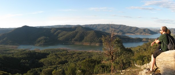
Lake Eildon. omg. sorry if i keep repeating omg. but OMG. like i wasn't impressed enough already. As soon as I reached Alexandra, I had a good feeling bout the place. quaint little town. nice name. Taking the turn into Ut Creek Rd enroute towards Lake Eildon I was going 'wow' every 5 seconds. While I was already going 'wow' every 1min on the usual highway roads, along Ut Creek Rd the sceneries were brought right next to me, & the closer I got to Lake Eildon the rolling hills were all around me by now & i just wanted to stop the car & run up them. Hills do that to me. As I rolled downhill towards Eildon I made mental note to snap pics on way out (but didn't as it was already getting quite late!) still I managed a few, so rewrote mental note (next trip!):

My poor attempt at capturing the Ut Creek Rd rolling hills - trust me the hills goes on for ages! Love them!

Reaching Lake Eildon - I was already v v exhausted from the heat & long drive. I had this map for a quick hike along Estate Spur Track becoz i saw the stunning pic below from Bushwalkingblog.com.au - I knew I had to check it out.. eventho it was already 5pm.

Copyright of Bushwalkingblog.com.au

I drove slowly along the lake-side studying the terrains of the surrounding hills. I tot of the run the next day & tot a siesta by the lake-side is better idea but best spots were taken up by campers & lake-activity goers. I was never gonna be happy if i didn't at least try to explore. The eve light would've lighted up the terrain & it would make beautiful pictures so I decided to hike the shortest route from the road up towards Estate Spur Track after pondering for 15mins. Yes it was quite a scramble, and yes the headache came back for a while, and yes I have NO REGRETS.. coz check out the views! OMG!


Here's my version vs the one below from Bushwalkingblog.com.au :) clearly there's even more stunning views if I went further west along the track... SIGH.. NEXT TRIP!
Copyright of Bushwalkingblog.com.au

And with rolling hills like these why isn't there a Lake Eildon Ultra Trail you wonder... waiting for me to organise it that's why! 
It was a reluctant departure from Eildon, the sun was still ever intense but I felt none of it after seeing what i saw. I scrambled down & left the place around 6pm - in time to reach Buller by 8pm latest.

Buller. I tried very hard not to be distracted by the views as I sped towards Buller. But enroute to Bonnie Doon - the cows were calling out to me & I did stop to take few pictures at this beautiful open plain somewhere..


Then of course I came across Bonnie Doon - which I have not planned to visit nor knew about previously & was just flabbergasted how scenic the place was. I had to leave it for the next day on the return journey. But I literally drove with my jaw dropped all the way towards Mansfield & Mt Buller Tourist Rd where I took a picture of the great Buller basking in the evening light... I REALLY wanted to stop & spend ages getting the right composition for it but no can do.. this shot was literally emergency stop & grab!


Fortunately there was no further distractions along the way & I pulled into Navy Ski lodge at last at 8pm - the view from the lodge was another vista.. and I was privileged to be standing there witnessing the fading hues of purple...


Few more pictures of the magnificent sunset & I grabbed my stuff from the car, headed in to meet the wonderful Mirabella folks who had more or less finished dinner. I sat myself down, ate my pasta & salad, made small talks & crashed early for the night... I knew the day had exhausted me but I couldn't really sleep until 3am or so - it was a mixture of the dark chocs & the new environment & the excitement from what I went through in the day which was nothing short of magical.. & of course the 21k of Buller which would demand every ounce of tenacity & guts from me in a few hours time!

PART 2 - 21k OF ASKING WHY!

Bonnie Doon. An unplanned discovery! Bonnie Doon sits around the northern region of Lake Eildon, and I made it a point to visit the region after the Buller run. I pulled into Dry Creek Rd which cuts across the lakes in this region - and despite the unrelenting sun & sore legs I was energized seeing the views..


Stunning terrain isn't it.. 
Saw a roadkill wombat here too.. :P
 How cool is this for a postbox eh? 
Rolled up hay.. always picturesque!
Leaving Dry Creek Rd & after crossing the Maroondah Highway bridge over the lake, I turned into Maintongoon Rd that took me meandering along the edge of the lake - LOVED the drive, lake-activity goers were everywhere with their boats, skis, barbeques.. living the good life.

The drive was nestled between the hills & the lake - I checked my map & it showed that Maintongoon Rd cuts across to Alexandra anyways so I decided to brave it, but unfortunately my adventure was stumped coz the roads turned into dirt tracks shortly after leaving the lake area. SIGH. BACK with a 4WD next time then!

Anyway - that concluded my reservoir hopping road trip & experience up at Buller - all in 2 days. Pretty amazing if I may say so! Quick takeaways from the entire experience:

1) One can actually run up Buller!
2) Small cars are great for whizzing around little lanes
3) Cows are more photogenic than horses
4) It's a big beautiful world out there
5) Get a good pair of shades & hat
6) Stay hydrated & DON'T munch dark chocs for supper!
7) Live life & have no regrets!

Till the next adventure folks! Thanks for reading!

More Pictures HERE!

Thursday, November 22, 2012

Blistex Ultra Lip Balm SPF30+


Smells lemony this Blistex lip balm I got for myself. Will be using such an ultra lip balm this weekend up at Buller.. where UV index is either extreme or very high O_o

One thing for sure running here in oz, my lips are always dry. And last thing I want are getting them burnt too! Fingers crossed this extreme lip balm will solve all woes!

26Nov update: YES IT WORKS - BUY IT! took it up to the mountains & lips never once complained.. in fact, without applying it now & back at sea level - the lips are dry & uncomfortable. Looks like this will need to be part of my daily make-up accessory :)

Published with Blogger-droid v2.0.4

Monday, November 19, 2012

Countdown to Buller - Pace Planning

Buller here I cometh! can't think of a better way to visit Buller for the first time really. :)

Here's my rather amateur study of the slopes & pace planning.. (never been to Buller so won't really know how accurate my assessment of the terrains are - until Fri nite)

1.5k in total steeps?

steeps 2k in total? 

5 steeps around 1k in total?
So lets say for every steep - we give it 15min/km pace, we have around 4.5k of steeps
The rest we decrease speed by every 0.5min/km pace every 1/3 of distance
So 4.5k steeps, 16.5k normal

Steeps
Steeps 4.5k x 15min/km = 1hr 7 min 30 sec

Normal
Normal 16.5 divide into 3 zones = 5.5km per zone
First 5.5km - 6min/km = 33min
2nd 5.5km - 6:30min/km = 35min 45sec
3rd 5.5km - 7min/km = 38min 30sec
Total = 107min 15sec

Grand total = 1hr 47min 15sec + 1 hr 7min 30 sec = 2hr 54min 45 sec

So expected time is 2:50 to 3 hours

First check point 7k, you should expect 42-45min 
2nd check point 14k, you should expect 50-55min, total = 1hr 32min - 1hr 40min 
3rd check point 21k, you should expect 52:30 + 24:30 = 1hr 17min, total = 2 hr 49min - 2 hr 54min

First 7k, you should feel fresh still
2nd 7k, you should feel the strain
3rd 7k, you should be gritting your teeth

Makes sense?


Friday, November 16, 2012

The Ultra Dandenong Project - Sherbrooke & Olinda

I've been having wild plans & woke up one day thinking whether it's actually possible to plan an ultra route (50k?) around the dandenongs, and it has fuelled my process of discovery of this national park since.. so Dandenong is split into 5 zones: Sherbrooke, Olinda, Mount Evelyn, Doongalla, Fern Tree Gully.. as seen here:

So I was thinking - could it be possible to run, let's say, from Upper Ferntree Gully station, into FernTreeGully & find some path through to Doongalla, popping out perhaps Olinda & eventually back south towards Sherbrooke & complete an ultra distance & live to tell the tale. Or vice versa! It'd be one helluva feat that's for sure.


Sherbrooke


So I've been to the Dandenong twice to date - first trip was to Sherbrooke, covered only the north-western portion... here's my garmin track:

Map 1: Big portion of Sherbrooke still unexplored.. but in light of the Ultra LSD, the first part of the area I covered seem logical. To link up with Olinda we'll need to cut east into Sherbrooke Road. Most likely through Alfred Nichols Memorial Gardens & traverse along Sassafras Creek, link up with Perrins Creek + Howard Rd 
When I went it just rained the night before so it was nice soggy trails on the day, here are some pics to give you an idea how this particular section looks like.. pretty nice:

Ferns galore! This was along Hillclimb

This was in the Hackett Track zone, wider clearer trails.. pretty decent for runs.

Olinda


I made a separate trip to Olinda - took a bus from Upper Ferntree Gully & started the exploration from Olinda town itself. I walked towards the National Rhododendron Garden & then south towards R J Hamer Forest Arboretum. Coming from Olinda, you have to walk through either one to get to Dandenong National Park (Olinda Region).

Map 2 : from Map 1's description, you can see at the bottom of this map Perrins Creek & Howard Rd... and see how it links up with the Arboretum. That's the next adventure I guess.. to explore whether it's possible to link these two regions up via this route. 
National Rhododendrum Gardens - beautiful place to bring your mom!
There was a sign 'Scenic outlook' at the start of Chalet Rd - they weren't kidding! :)
Well - I sat here for a good 15mins admiring the view. Pictures don't do justice to sceneris as we all know.
Happy me & unmarked trail leading down towards Mathias Rd.
Flowers all stretched out for a bit of sun.. :) 
This was the furthest east I went - the track is Board Track that fences up the forest region surrounding Silvan Reservoir - now I know it's not accessible (my mission was to try to reach the reservoir, now I know it's not possible via this route!). If I persevered along Silvan Rd, I would've reached the reservoir eventually but I wasn't prepared to go that far this trip.
A blue-tongue lizard (a big one too!) sunbathing along Mathias Rd.. 
Knackered. Back waiting for the train at Upper Ferntree Gully station. 
Well basically what I've found out so far:

1) The major busy roads are Mt Dandenong Tourist Rd & Monbulk Rd (ie. can't run/hike these)
2) If I want bus service as back-up plan then it needs to be along these 2 main roads
3) Scenic spots (to date) - One Tree Hill Junction with Mt Dandy Tourist Rd, Monument Trek, Chalet Rd
4) Silvan Rd is a long gravel downhill - hard on the knees - avoid
5) Most like Sherbrooke-Olinda route will be this:

Map 3: 23km in total, good elevation challenge, 3 scenic spots - One Tree Hill Rd junction, Chalet Rd, Silvan Reservoir, brings us back towards main road where I can catch a bus back towards train station. I think this would be a good Part 1 of the Ultra Dandenong Project! 

Next, will need to find out:

1) Whether can link up Sherbrooke Rd & Chalet Rd via intended route as per Map 3
2) Best forest scenic route from RJ Hamer towards Silvan Reservoir
3) Mt Evelyn, Doongalla & Ferntree Gully regions

Stay tuned folks!